Projects
Current Projects
Private sector perspectives on built environment resilience | ARISE-US


This project aims to understand how private sector companies view resilience as it relates to (1) their own continuity of operations and (2) to built-environment resilience more broadly. We also seek to document the tools private sector companies are using to advance resilience in their industries and understand potential incentives to increase resilience in practice. This project is a collaboration with a team from ARISE-US, a private sector alliance for disaster resilient societies through the United Nations Office for Disaster Risk Reduction. ARISE-US is a fiscally sponsored project of the Social Good Fund.
CIVIC: Accelerating coproduced flood resilience in rural levee communities | National Science Foundation


Flooding is the most frequent and costly natural hazard in the United States. Protection from flooding, especially for rural and small communities in Pennsylvania, depends on levees put up and maintained by local authorities. Many of these are not accredited by FEMA due to complications in the accreditation process and lack of the means and knowledge of local communities on how to evaluate levee integrity. Unaccredited levee systems saddle communities with high flood insurance rates and could result in potential danger to communities and the surrounding area from inadequate levee management and/or construction. This Civic Innovation Challenge (CIVIC) planning process uses rural areas in Pennsylvania as a pilot to bring scientists and rural/small communities that own levees together with engineering firms, levee evaluation experts, and state and regional stakeholder entities to co-design tools and a process that provides improved flood resilience and levee safety and management for rural communities. A goal of the project is also to help communities with unaccredited levees navigate the accreditation process.
Geotechnical data fusion for improving AI subsurface predictions | CIAMTIS U.S. DOT Region 3 University Transportation Center


The goal of this project is to evaluate the efficacy of, and improve subsurface predictions from, the publicly available data repository and ML-driven predictive tool Geosetta. We have conducted geophysical surveys using Multichannel Analysis of Surface Waves (MASW) testing at multiple locations on Penn State’s campus, and are leveraging data from an existing ~5km long Distributed Acoustic Sensing (DAS) cable already in place on campus. We are comparing the geophysical site characterizations with the predictions made by Geosetta, and ground-truthing our analyses with existing borehole data. The deliverables of this project include: a high-quality geophysical dataset, the first of its kind, to be incorporated into Geosetta; the addition of 842 historic geotechnical records in Pennsylvania to Geosetta (collected by PennDOT and geolocated using scripts developed in this project); a class project developed for CE 435: Foundation Engineering that requires students to use Geosetta to predict subsurface conditions at a site of interest, bolstering the AI-skills of students who will shortly be entering the geotechnical workforce.
Visualizing inland flood hazard in the face of climate change | Institute for Energy and the Environment


Communication of true flood risk is critical for communities facing a changing climate. Flooding is one of the most common and costly type of disaster in the US, and it is becoming more frequent and severe due to climate change. Simultaneously, infrastructure built to protect communities from flooding is aging and deteriorating: the American Society of Civil Engineers 2021 Report Card gave U.S. levee infrastructure, which protects ~17 million people and $2.3 trillion of property, a grade of D. Neither FEMA flood hazard maps nor existing levee infrastructure are equipped for impacts of climate change that will drive more frequent and severe floods in the future. Further, our research indicates that common methods of flood risk communication, such as static 2D inundation maps, are not as effective at communicating true flood risk compared to visualizations that more sincerely represent hazards and impacts. Failure of a levee system, for instance, can cause catastrophic damage to communities that thought they were protected. Adequately modeling and depicting this hazard may present a more realistic scenario that increases the salience of flood risk.
This project will integrate mature research in three distinct areas (visualization, hydrologic modeling, and geotechnical engineering) in a novel and transdisciplinary way by applying state-of-the-art 3D visualizations to rigorous scientific models of flood hazard and levee stability for a leveed community in Luzerne County, Pennsylvania. The methods developed in this project will be easily transferable to other study areas of interest.
Recent News: Growing Impact podcast discusses communicating inland flooding through visualizations
CLIMA: Climate-resilient infrastructure adaptations for maladaptive levee networks | National Science Foundation


Millions of people and trillion dollars of property in the US are protected from flooding by levee systems. However, most federally monitored levees fall short of minimum accreditation standards. Further, climate change exacerbates flooding, likely making current levee protection inadequate in the future. Upgrading and extending existing levees require substantial investments and may not lead to net positive effects for all communities across a given river network. This CiviL Infrastructure research for climate change Mitigation and Adaptation (CLIMA) project aims to address this problem by exploring a theory-guided systems modeling framework for designing climate-resilient levee infrastructure that supports floodplain communities in an equitable way.
The project focuses on two interrelated questions: (1) How interactions between a levee network’s performance, future climates, natural infrastructure, and behavioral feedback drive changes in flood risk across communities; and (2) How design adaptations reimagine a levee network that supports equitable, resilient, and sustainable communities. To address them, the project creates a novel systems modeling framework to evaluate levee adaptation strategies, considering factors often overlooked in levee decision-making, such as natural flood infrastructure, variability in levee performance, climate change, unintended consequences of levee construction, and social equity. This framework sees levees as part of a larger adaptive network, where levee decisions made in one community affect others in the same watershed. Through the adaptation lens, the project advances knowledge of the potential of natural flood infrastructure to reduce the need for levees and achieve co-benefits (such as reducing freshwater pollution), the geotechnical factors that drive levee performance at the watershed level, and the interventions and policy options for adapting levees to changing flood conditions. These advancements have the potential to benefit floodplain communities nationwide by facilitating the identification of resilience-building strategies. By utilizing extensive biophysical and social datasets, including new sources like geotechnical field and community surveys, the project creatively couples computational models of natural infrastructure, levee infrastructure, flood inundation risk, and levee decision-making. This integrated approach yields detailed roadmaps of levee adaptations and levee analytics, allowing for better-informed decisions that prioritize equity, resilience, and cost-effectiveness.
Towards linking hydro-climatic change and earthquake hazard | Penn State & University of Auckland


Recent years have brought a momentum shift in climate action: we are now keenly aware of the threat of climate change to our infrastructure and communities. Rising sea levels, warming temperatures, and more frequent and severe storms are well-known impacts of climate change that have been experienced worldwide, and most significantly in coastal areas. In many of these regions, earthquake hazard is also significant. Changes in soil and hydrological conditions due to climate change will impact ground behavior during earthquakes. This project will explore the impacts of hydro-climatic change on the hazards associated with earthquake ground shaking through the lens of a case study region. The Hawke’s Bay region on the East coast of Aotearoa New Zealand’s North Island has high hazard, due to its proximity to the Hikurangi Subduction Zone. The 1931 Hawke’s Bay Earthquake caused severe damage to the city of Napier and remains the deadliest natural disaster in the country's history. More recently, the unprecedented Cyclone Gabrielle moved across the North Island in Feb. 2023, through Hawke’s Bay, and caused an estimated $8 billion in storm and flooding damages. As communities in Hawke’s Bay begin to rebuild post-cyclone, it is paramount that adaptations for flooding and storm events also incorporate considerations for the ongoing and evolving seismic threat to the region. The outcomes of this proposed project will support the building of sustainable and resilient communities that can anticipate and mitigate the multi-hazard threats of the future.
Recent News: Second round of Penn State-Auckland seed grant recipients complete projects, Penn State Global announces Collaboration Program awards with Auckland
Past Projects
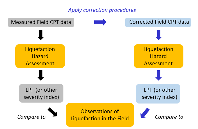
Assessing efficacy of multiple thin-layer correction procedures | National Science Foundation
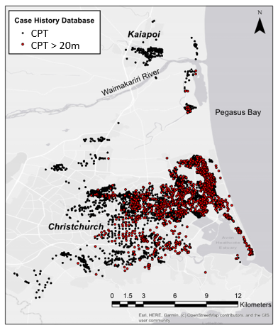
Procedures to account for multiple thin layer effects have been proposed by several researchers, but their efficacy on a large scale has not yet been assessed. In Yost et al. (2021), the efficacy of three multiple thin layer correction procedures is assessed directly (by applying them to a set of CPT calibration chamber test data) and indirectly (by applying them to a database comprised of 9,150 CPT-based liquefaction case histories compiled from three different earthquakes that occurred in Canterbury, New Zealand). The results from the direct comparison show that the three procedures considered do not accurately identify and characterize soil layers less than 40 mm thick. The indirect comparison indicates that the procedures do not improve the accuracy of liquefaction evaluations for the large case history database. Furthermore, the application of the procedures actually decreases the accuracy of liquefaction evaluations for highly interlayered soil profiles – exactly the opposite of the procedures’ intent. This was not surprising, as the highly interlayered profiles in the Canterbury dataset typically contain many layers less than 40 mm thick. The results from this work highlight the need to develop more accurate multiple thin layer correction procedures.
Numerical modeling of CPTs for correction procedure development and validation | National Science Foundation
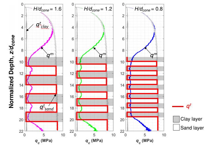
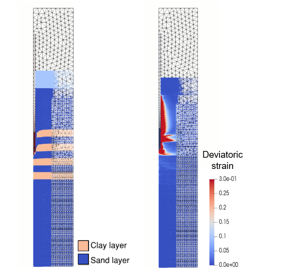
To complement the few available pairs of qm and qt data required to develop and validate multiple thin layer correction procedures, Kaleigh is developing a database of numerical CPT data using the Material Point Method (MPM). MPM is a continuum-based numerical method in which the domain is discretized into a set of “material points” that are free to move through a background computational mesh. In this way, MPM is particularly suited to large deformation problems, like cone penetration. I developed a numerical model of CPT in layered soils using the Anura3D MPM code.
In Yost et al. (2022), the MPM model is validated against calibration chamber data and shown to be capable of replicating multiple thin layer effects in profiles comprising more than 25 soil layers. This is a significant advancement compared to previous numerical studies that have only considered two or three soil layers, and is more useful for the development of multiple thin layer correction procedures.
To develop the database of qm and qt pairs, CPTs are simulated in soil profiles with varying layer geometry, thickness, stiffness, and overburden pressure. This database and its use for developing and validating multiple thin layer correction procedures will be shown in a manuscript currently in submitted to Earthquake Spectra.

Development of new multiple thin-layer correction procedures | National Science Foundation
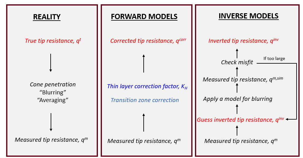
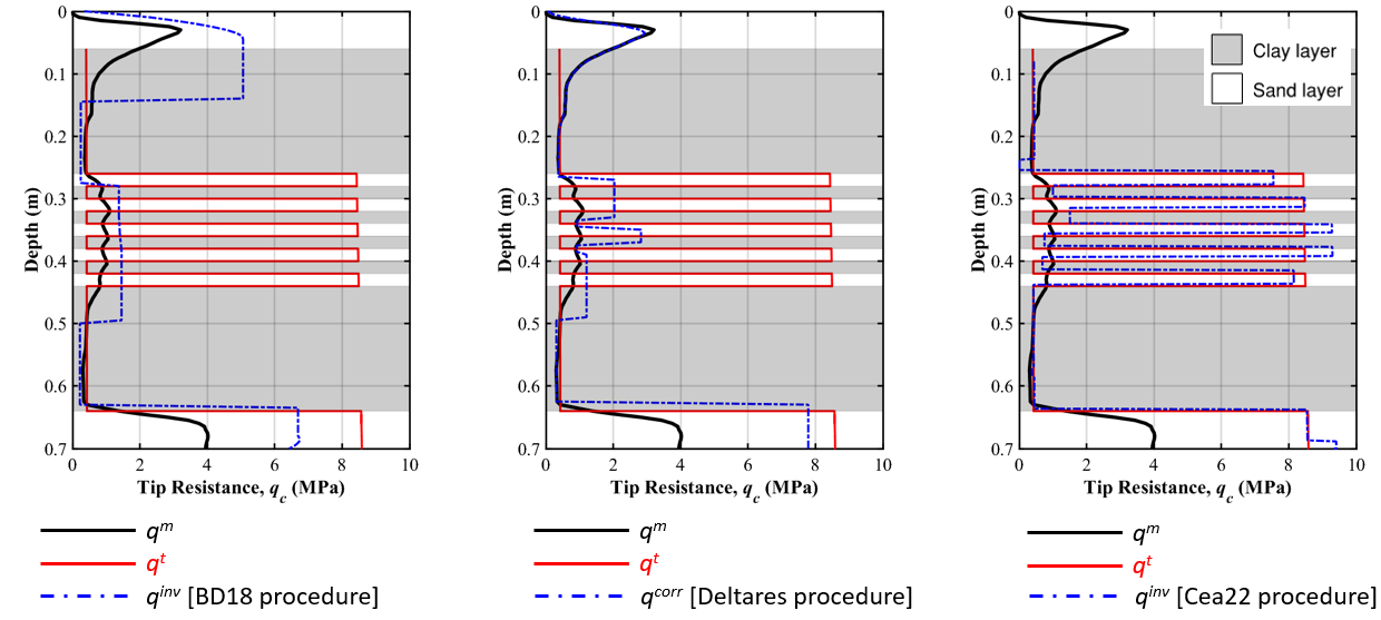
Motivated by the findings discussed in Yost et al. (2021), and in collaboration with the computational math group at Virginia Tech, Kaleigh is working to develop new and more effective multiple thin layer correction procedures. In Cooper et al. (2022), a new inverse method is proposed to determine true tip resistance. Inspired by the inverse method proposed by Boulanger and DeJong (2018), this method poses the inverse problem in a new way, assuming that the true tip resistance profile is a piecewise constant function with depth (i.e., only two degrees of freedom: layer location and layer tip resistance). This reduces the computational cost of the analysis. Results indicate that the Cooper et al. (2022) method is able to better identify thin interbedded soil layers in calibration chamber data compared to existing procedures. Matlab scripts to perform the Cooper et al. (2022) procedure are available on GitHub.
Future work will show the efficacy and limitations of the Cooper et al. (2022) method using a large liquefaction case history database and a numerical CPT database.